MetService upgrades warnings for North Island east coast, evacuations looming as river level rises
- Publish Date
- Thursday, 22 June 2023, 4:40PM

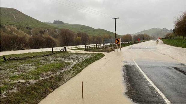
Flooding on State Highway 2 near Otoko. Photo / NZ Police
Gisborne District Council is advising residents in the small town of Te Karaka to self-evacuate as MetService upgrades the East Coast’s heavy rain warning to red.
MetService has issued severe weather warnings for a number of locations, including Gisborne. On Thursday afternoon, MetService elevated the region to its most serious warning level — a red heavy rain alert.
From Thursday at 3pm through Sunday at noon, there is a red heavy rain warning. According to MetService, the wettest days will be today and Friday.
As of 4pm this afternoon, Waipaoa River level was just over 8 metres, according to the water level chart of Gisborne District Council’s website. According to the council, the river will burst its banks when the level reaches 8.2 metres.
MetService advised residents to expect 200 to 300mm of rain to accumulate about and north of Tolaga Bay, 100 to 150mm about the ranges farther south, and 50 to 100mm about coastal areas south of Tolaga Bay in addition to what has fallen already.
Thunderstorms are also possible. Large-scale flooding has also caused road closures.
At 1 pm, Gisborne District Council sent out a text message to residents warning them of the water level, with the river at 7.3m.
“The evacuation level for Te Karaka is 7.5m,” it said.
Waikohu Civil Defence has urged residents who were in doubt to “self-evacuate”.
Up to 75 hours of non-stop rain is set to inundate North Island’s East Coast as continuous heavy downpours threaten to bring more flooding and slips to the region.

This morning watches and warnings were lifted for Northland and north Auckland.
Coromandel Peninsula, Bay of Plenty west of Te Puke and Tairāwhiti have been placed under orange heavy rain warnings.
Whereas Coromandel and Bay of Plenty could see over a day of downpours, the regions have been placed under a 30-hour warning from 9am until 3pm tomorrow.
Tokomaru Bay residents are being told by the local civil defence teams to be prepared with enough food and water for four days in case the town gets cut off due to upcoming severe weather.
State Highway 2 Matawai to Te Karaka remains closed due to flooding.
Waka Kotahi NZ Transport Agency is advising motorists to avoid the area or delay their journey if possible.
Thames-Coromandel District Council this morning warned motorists travelling on the region’s roads to watch for flooding and debris.
Roads affected by overnight flooding on the North Island’s East Coast are starting to reopen.
The arterial State Highway 35 from Okitu to Ruatoria is now open after being closed due to flooding at 4pm yesterday.
Waka Kotahi NZ Transport Agency is advising road users to drive with caution.
Earlier, in a warning, Tairāwhiti Civil Defence said streams and rivers could rise rapidly, and slips and flooding were possible.
Gisborne’s State Highway 35 was badly impacted by extreme weather events earlier this year, and flooded yesterday on the Mangatuna side of a new bridge.
By 4pm yesterday, 55mm of rain had been recorded in the Raukmara Range in northern Tairwhiti, most of it since noon, according to MetService.
MetService meteorologist Alwyn Bakker said the prolonged rainfall in Bay of Plenty, Coromandel and Gisborne caused by the low-pressure system from the Tasman Sea may cause flooding and slips even if warning criteria were not reached.
A low-pressure system just to the west of Northland on Wednesday afternoon is responsible for the rain, which is predicted to gradually move across the northern part of the country through Saturday.
A heavy rain warning is in place for Northland which began at 8pm yesterday evening and is expected to last until 5am this morning.
Between 9am and 5pm yesterday, Kaitaia received about 50mm of rain, with about 20mm falling within the hour from 11am to noon.
MetService warned a further 50 to 70 mm of rain was expected to fall last night, with peak rates of 15 to 25 mm/h, particularly in the north and west. Thunderstorms are also possible.
North Auckland, including Great Barrier Island, was placed under a heavy rain warning by MetService at 9pm last night, which is expected to last until 9am today.
Throughout today, Auckland is forecast to see periods of rain or showers, with some heavy and thundery falls. The downpours are set to linger into the weekend.
As the low-pressure system that’s causing the weather moves south, a 35-hour watch is in effect for the Coromandel Peninsula and Bay of Plenty, which began at 1am this morning and is expected to last until 12 pm on Friday.
140 to 180 mm of rain is expected, especially about Coromandel Peninsula, with peak rates of 15 to 25mm/h.
Weather forecasting agency Niwa reported the storms impacting these areas would be strong, producing heavy rain and possibly an isolated tornado.
Niwa also reported that 60,000 lightning strikes were recorded near the top of the country in the Tasman Sea.
Keep up to date with the latest weather news and updates at nzherald.co.nz.
This article was first published on nzherald.co.nz and is republished here with permission.
Take your Radio, Podcasts and Music with you

